How Global Warming Can Start an Ice Age

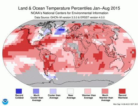
ArcticColdSpotIn the last month, there’s been much attention to a cool patch in the North Atlantic Ocean, where record cold temperatures over the past eight months present a stark contrast to a globe that is experiencing record warmth. And although there is certainly no consensus on the matter yet, some scientists think this pattern may be a sign of long-feared consequences of climate change — a slowing of North Atlantic ocean circulation, due to a freshening of surface waters.

The cause, goes the thinking, would be the rapidly melting Greenland ice sheet, whose large freshwater flows may weaken ocean “overturning” by reducing the density of cold surface waters (colder, salty water is denser). If cold, salty waters don’t sink in the North Atlantic and flow back southward toward Antarctica at depth, then warm surface waters won’t flow northward to take their place.

Now, two new studies just out in Nature Geoscience help to underscore why scientists have a good reason to think this sort of thing can happen — namely, because it appears to have happened in the Earth’s distant past. And not just once but on multiple occasions.

Source: Why the Earth’s past has scientists so worried about the Atlantic Ocean’s circulation – The Washington Post

Back in 2007, I posted this sun spot research that  predicted that by 2020 we would be cooled by a low solar activity ( a cooler sun) period. http://terryorisms.com/2007/06/23/read-the-sunspots/   

Extreme Weather – The New Norm

The climate will swing to extremes as it tries to find a new equilibrium, in response to the warming climate. Siberian winters will be colder, heat waves extended, etc. This report says that if you are in a rainy location, expect more deluges, and if you live in a dry area, expect more droughts. Specifically, the new study found that although the 14 climate models differ when it comes to the amount of rainfall in individual locations such as cities, over larger areas, they all point to the same average picture. That is, for every single degree Fahrenheit the global average temperature climbs, heavy rainfall will increase in wet areas by 3.9 percent, while dry areas will experience a 2.6 percent increase in time periods without any rainfall.

Rain will get more extreme thanks to global warming, says NASA study | The Verge.

Lenticular Clouds Over Mt. Rainier

Credit & Copyright: Tim Thompson

Moist air forced to flow upward around mountain tops can create lenticular clouds. Water droplets condense from moist air cooled below the dew point, and clouds are opaque groups of water droplets. Waves in the air that would normally be seen horizontally can then be seen vertically, by the different levels where clouds form. On some days the city of Seattle, Washington, USA, is treated to an unusual sky show when lenticular clouds form near Mt. Rainier, a large mountain that looms just under 100 kilometers southeast of the city. This image of a spectacular cluster of lenticular clouds was taken in 2008 December. Click picture to enlarge. Credit & Copyright: Tim Thompson

via APOD: 2012 November 4 – Lenticular Clouds Over Washington.

Most Powerful Storm Ever Recorded

On Oct. 12, 1979, Super Typhoon Tip’s central pressure dropped to 870 mb (25.69 inches Hg), the lowest sea-level pressure ever observed on Earth, according to NOAA. Peak wind gusts reached 190 mph (306 kph) while the storm churned over the western Pacific.

Besides having unsurpassed intensity, Super Typhoon Tip is also remembered for its massive size. Tip’s diameter of circulation spanned approximately 1,380 miles (2,220 km), setting a record for the largest storm on Earth. The storm’s huge diameter was exactly the same as the distance from New York City to Dallas.

Accuweather’s Mark Mancuso has the details: Super Typhoon

Earth’s Strongest, Most Massive Storm Ever.

Tornado Of Fire Caught On Tape In Australia Fire Twister

THERE’S something mean and magical about Australia’s Outback. An Alice Springs filmmaker captured both when a whirlwind of fire erupted before his eyes.

Chris Tangey of Alice Springs Film and Television was scouting locations near Curtin Springs station, about 80km from Ularu, last week when confronted by a fiery phenomenon. He had just finished his tour of the station when workers encountered difficulties with a grader. So he went to help them. A small fire was burning in nearby bushland, so Mr Tangey decided to start filming. He caught the sight of his life. A twister touched down on the spot fire, fanning it into a furious tower of flame.

“It sounded like a jet fighter going by, yet there wasn’t a breath of wind where we were,” he told the Northern Territory News. “You would have paid $1000 a head if you knew it was about to happen.”  The column of fire danced about the landscape for about 40 minutes, he said, as he and the station workers stood transfixed. There was talk of making a quick getaway, Mr Tangey said. But everyone was too hypnotised to feel scared – and he continued furiously filming. “The bizarre thing was that it rarely moved,” he said. “These things just stood there because there was no wind to move them … but it was flickering incredibly fast.”

Darwin weather forecaster David Matthews said small twisters were common in isolated areas. But the fiery vortex was highly unusual. “The flames would have assisted by trying to suck in air and that could have helped generate those circular winds,” Mr Matthews said.

via Tornado Of Fire Caught On Tape In Australia Fire Twister – YouTube.

“Kelvin–Helmholtz instability” Covers Florida Condos

Panama City Beach, Florida — Fog rolls up along the shore of Panama City Beach, Florida on Feb. 5th, 2012. Maria found this picture,  but Peggy Sadler shared the link below to the full set.

via PhotoBlog – Spectacular ‘cloud tsunami’ rolls over Florida high-rise condos.

Terrifying Cloud Threatens Neighborhood

The father-of-three said: ‘It was a nice evening and the sun was shining when I suddenly heard claps of thunder, which was strange.

‘My wife went to look out the front door and saw the clouds blowing up from the south.

‘I took one look and headed back into the house to get my camera.

‘We watched the storm for a few minutes when I noticed that the cloud was starting to spin.

‘I got my ladder and climbed up on my roof to get a better view.

‘It never got the momentum to create a tornado, but it did look like it was going to happen before out eyes.

‘We watched for 45 minutes as it slowly moved back into cloud formation.’

via Terrifying moment vast cloud threatened to engulf whole street | Mail Online.

Extreme Weather – The New Normal?

2011 Blizzard

The Earth’s northern magnetic pole was moving towards Russia at a rate of about five miles annually. That progression to the East had been happening for decades.

Suddenly, in the past decade the rate sped up. Now the magnetic pole is shifting East at a rate of 40 miles annually, an increase of 800 percent. And it continues to accelerate.

Recently, as the magnetic field fluctuates, NASA has discovered “cracks” in it. This is worrisome as it significantly affects the ionosphere, troposphere wind patterns, and atmospheric moisture. All three things have an effect on the weather.

Forget about global warming—man-made or natural—what drives planetary weather patterns is the climate and what drives the climate is the sun’s magnetosphere and its electromagnetic interaction with a planet’s own magnetic field.  At the conclusion of this alarming article comes this prediction…

One of the most stunning signs of the approaching Ice Age is the world’s precessional wobble has stopped.

So, the start of a new Ice Age is marked by a magnetic pole reversal, increased volcanic activity, larger and more frequent earthquakes, tsunamis, colder winters, superstorms and the halting of the Earth’s precessional wobble.

Unfortunately, all of those conditions are being met. Continue reading “Extreme Weather – The New Normal?”

Blame the Cold Winters on Global Warming

As global temperatures have warmed and as Arctic sea ice has melted over the past two and a half decades, more moisture has become available to fall as snow over the continents. So the snow cover across Siberia in the fall has steadily increased.

The sun’s energy reflects off the bright white snow and escapes back out to space. As a result, the temperature cools. When snow cover is more abundant in Siberia, it creates an unusually large dome of cold air next to the mountains, and this amplifies the standing waves in the atmosphere, just as a bigger rock in a stream increases the size of the waves of water flowing by.

The increased wave energy in the air spreads both horizontally, around the Northern Hemisphere, and vertically, up into the stratosphere and down toward the earth’s surface. In response, the jet stream, instead of flowing predominantly west to east as usual, meanders more north and south. In winter, this change in flow sends warm air north from the subtropical oceans into Alaska and Greenland, but it also pushes cold air south from the Arctic on the east side of the Rockies. Meanwhile, across Eurasia, cold air from Siberia spills south into East Asia and even southwestward into Europe.

via Bundle Up, It’s Global Warming – NYTimes.com.

%d bloggers like this: